Tuesday, August 23, 2016

From Dover Heights to a sad place


As I get older, and spend more time in magnificent harsh and empty landscapes, I am less and less tolerant of our urban environment.  So it comes as no surprise to me that this was not one of my most enjoyable walks, lined as it is on one side for much of the way with houses and apartments, testament to the ugly triumph of wealth over aesthetics.


A bungalow/castle?  What were they thinking?


But these are as nothing compared with the ugliness of a 1960s Harry Seidler apartment building; breathtaking in its incompatibility with the soaring cliffs and thundering ocean.  I don't understand brutalist architecture.  I understand the lure of brutal landscapes, and even of brutal weather, but not this.  At least it's white.


This walk commences at Dover Heights Reserve, at the end of Lancaster Rd.  On a weekday at least, parking is easy.  The reserve is an uneven strip of grass separating the houses bordering it from the cliff edge; insurance no doubt against a cliff fall taking millions of dollars of real estate into the sea.  You arrive there by walking through a gate in a rather charming, if dilapidated, white picket fence, then descending a set of wooden stairs.  If you're bothered by stairs that aren't closed in, you might have some trouble here. 


At the end of the reserve, it's back through another iteration of the picket fence, a brief walk through suburban streets, then back onto the clifftop at the southern edge of Diamond Bay, descending more wooden stairs next to that Seidler building.  In these times of great concern for community safety, the entire cliff edge is fenced, but there is evidence of earlier attempts to hold the masses back from a lemming-like leap over the edge.  I particularly liked the daring of this gateway to a small rock platform, with the swirling sea below. 


Diamond Bay is in fact a V-shape, and according to the sign, no-one knows why it's called Diamond Bay.  There are various theories, most of which have been refuted.  It's a small gash in the unstable cliff, lined with ferns and tinkling waterfalls.  It's very pretty from above, and worth looking down to the shoreline below.  Probably this was my favourite moment of the walk.  There is an apartment block built across the apex of the V, right up to the cliff.  The end apartments must be dark and damp, but being able to reach out to the ferns from your balcony probably goes some way towards recompense for the mould.


After skirting Diamond Bay, you stick to the clifftop from there on.  It's an attractive but largely manicured walk from here, with mown grass, seats, and plenty of dog walkers.  Just north of Diamond Bay is Christison Park, a suburban football field which has to be distracting for the spectators, if not the players as well.  Stand at its verge and look west all the way to the Bridge; turn 180 degrees to look out to the Pacific Ocean.


Then comes a bit of history.  The Dunbar, a clipper carrying passengers and goods from England, arrived off the Heads on a stormy night in August 1857.  She failed to make it through into the Harbour, and instead foundered on the cliffs just south of the Gap.  Of the 122 crew and passengers, only one survived.  James Johnson, a crewman, managed to swim to a rock shelf, from whence he was rescued.  This shipwreck, and another soon after, led to the construction of the first lighthouse on South Head.


If you're thinking of a picnic lunch at some point, I advise you to stop around this area.  Once you get near to the Gap, the tourist hordes are in evidence even on a weekday, selfie sticks in hand, ridiculous pouting poses oblivious to the tragic reason the Gap is so well known.  Of course, if you really want to throw yourself off a cliff in Sydney, you don't have to go to the Gap to do it.  But the Gap is inextricably linked to tragedy and suffering, and for those in despair, it must beckon. 
 
 
And for Trevor Coombs, just after his 41st birthday earlier this year, it did.
 
Enormous resources have been put into protecting those like Trevor who come to the Gap to end their lives.  I found a report of a study from the University of Melbourne that found that increasing the likelihood of someone intervening, by the presence of fences, signs, crisis phones and such measures, can reduce the suicide rate in areas including the Gap by 90%. 


The Gap, on the sunniest of days, is a sad place for me, lightened only by the memorial to Don Ritchie, a legendary figure in the dark history of the Gap.  From his loungeroom, Don could see people scaling the fence to stand at the cliff edge.  He would go down, talk to them, invite them home for a cup of tea...  It is thought that his simple interventions of kindness saved hundreds of lives over the fifty years he reached out to those in need.

So, trying in vain to shake off the pervasive gloom of this place, I headed down the hill to Watson's Bay, to feel sand between my toes, have my picnic lunch and a cup of coffee.  The crowds increased.  I sat on the seawall and undid the plastic wrap around my lunch.  The seagulls descended.  They are feral, not helped by the tourist who thought it highly amusing to throw them an entire serve of chips, one chip at a time, whilst standing right next to me, as her husband photographed the screaming heckling fighting flock of birds.  I hurriedly ate my lunch, waving the seagulls away, put my shoes back on, and retreated to find a cup of coffee.  This can be had on the ferry wharf.

I headed back the way I came, with the Gap walking with me back to the car and home.


Sunday, June 19, 2016

The thirteenth day of the rest of my life

The day started badly.  My car had been recalled to have a problem with the seatbelt locking mechanism corrected.  With much planning ahead, I had booked it in to the local dealer, to begin and end the day there, with Walk #21 in the middle.  The first step to go awry was finding the service department.  Google had helpfully told me the dealer's address, on one side of Paramatta Rd.  Sadly, the service department is on the other side, and getting your car to the other side of Paramatta Rd at peak hour is not for the faint-hearted.

Consequently, I was later leaving the dealer than I had expected, and I still had two buses to catch to my starting point.  As I approached the first bus stop, a bus with my number on it pulled away.  I consulted the timetable, and realised that it was not the bus I had planned to take anyway, but the earlier one, spectacularly late.  So I settled in to wait for my bus, unconcerned by a short delay.  I should at that point have realised that, when one bus is 16 minutes late, the next one is unlikely to be unaffected by the same delays.  A pleasant if somewhat tedious wait in the sunshine on Great North Road ensued.  My bus, true to form, was similarly late, and they only run every half hour.  So of course I then missed my connecting bus, in a repeat of the scenario where it pulled away as I was almost at the bus stop, followed by another major delay in the arrival of the next bus.  All of which meant that it took me almost ninety minutes to travel from Haberfield to the other side of the Gladesville Bridge at Hunters Hill.  In hindsight, I could have walked that return trip instead and saved my Hunters Hill walk and bus fares for another day.

But finally I arrived at the start of the walk, at the top of Alexandra St in Hunters Hill.  The walk is designed to be one way, ending at the wharf at the bottom of the peninsula, but I had elected to do the return trip, so about 10 kms all up.  Make no mistake, this is at heart a very urban walk, with some lovely waterside parks and a bit of very famous bush thrown in.  The Joubert brothers, after whom a street is named, built, in the second half of the 1800s, many of the beautiful sandstone mansions that grace Hunters Hill today.  There is a Heritage Trail, with 40 plaques to be read, if you're a history buff.  For myself, I would have just loved to see inside some of those gorgeous dwellings.  I sneaked a couple of photos through a gate and down a driveway, the latter astonishing in its Italianate pretension.

But back to the walk itself.  The Book recommended the stained glass in All Saints Anglican Church as being some of the finest in the country, so I was eager to look inside.  But the doors were firmly closed against an unbeliever such as I so I walked on.  And there, around the corner, was the true ecclesiastical delight of the St Peter Chanel Catholic Church.  Only in the high end of town do you get your church blessed by the patron saint of haute couture.  I sniffed the air for the telltale scent, but there was only mown grass to be had.  The sunlight haloed over the rooftop confirmed I was indeed in exclusive company. 


 "Let your light so shine before men, that they may see your good works..."  Matthew 5:16


On the way, I had skirted the grounds of Passy House, built by the ubiquitous Jouberts for the French consul in the mid-1800s.  Coming back, I took a quick photo, through the gate, of the ornamental pond that graces its front driveway.  I now know that I was photographing the residence of Eddie Obeid.  I needn't have worried that he would be home.  I understand he's currently gracing the courtroom of our NSW Supreme Court on a small matter of Misconduct in Public Office (alleged, of course).  Poor Eddie, he lost a big conifer branch in the weekend storms, leading to the closure of the laneway down the side
Passy
of his house.  I ducked under the tape, after a quick assessment that the rest of the tree looked unlikely to fall at that moment.
 
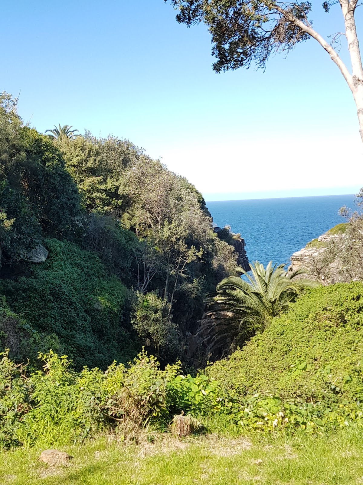
Leaving the Obeids to ponder the future of their lifestyle, I headed on down the hill, all the while considering that I would be coming up again later.  A set of stone steps leads to the delightful Mornington Reserve, with beautiful views over the Lane Cove River, sparkling in the sun.  Despite my public transport woes, it was still too early for lunch, although it would be a lovely north-facing spot for a picnic.  It's very secluded, with the only entries being fairly inconspicuous and steep laneways at either end.  Being there gives you an opportunity to see some of these magnificent mansions from the rear, and they are spectacular.  A bit of a security nightmare though I would have thought, a thought clearly shared by a small but very persistently loud dog that sounded the alarm of my presence.  Ignoring it and the attached resident, I paused for a while to drink in the view before moving on. 


The last house you see before heading out of Mornington Reserve revels in this marvellous rotunda.  Because it can.  I think there were three gardeners all working there when I went past.  It's not enough just to have money to buy the house, there's the upkeep to consider.


So, onwards and upwards to the famous Kelly's Bush.

In 1892, there was a smelting company established on the waterfront of the peninsula by one TH Kelly.  He set up a buffer zone of preserved bushland to allow public access to the foreshore.  Move on to 1967, when AV Jennings had other plans for the site after the smelting company relocated.  I remember AV Jennings well from my childhood.  It was a very prominent company that built a lot of new houses in the area where I grew up.  Probably on reclaimed bushland, though I never gave that a second thought (or even a first) at that time.  Anyway, AV Jennings wanted to build 147 units on the site, including three eight-storey tower blocks.  The Hunters Hill council said no and asked to acquire the rest of the site.  (It had already bought a small package for a park in 1956.)  In an echo of current planning practices, the State Planning Authority refused the request. 

An argument ensued.  The Hunters Hill Trust was established in early 1968 but, after prolonged negotiation, the Council, no doubt controversially, rolled over and agreed to a modified proposal of 56 residences.  The Trust marshalled its resources and succeeded in reducing that number to 25.

Enter the Battlers for Kelly's Bush, a group of local women - Liberal matrons who wouldn't look out of a place with a blue rinse. 

They met with AV Jennings and Robert Askin, then NSW Premier, to no avail, and were supported by a number of conservation organisations.  All to no avail.  Mr Askin was about to sign the rezoning into law.  At which point, they appealed to the Labor Council of NSW on 3 June, 1971.  It must have been a difficult decision for many of them to run counter to all their political beliefs about the Labor Party and the unions.  But it was the right one.  Two weeks' later, the BLF, under the Communist leadership of Jack Mundey and others imposed the first example of what we now know as a Green Ban.  An immediate stoush with AV Jennings erupted, which they ultimately lost.  Within the next year, 42 other Green bans were imposed across Sydney, leading to the preservation of areas such as The Rocks. 

Surprisingly, the skirmishes continued until 1983, when then-Premier Wran finally announced that the NSW government had purchased Kelly's Bush for open space for the community.  The Battle for Kelly's Bush was finally won, 12 years after it commenced.  My thanks to all of those women who defied convention and took a stand.

If you are taking this walk, it is not clear from the directions that, to find the entrance to the Lookout track through Kelly's Bush, you need to turn right at the end of Prince Edward Parade and head down the hill to the intersection with Tree Ave, where you will find the track.  Or you could do what I did, ignore the 'track closed for maintenance' signs, go straight ahead at the end of Prince Edward Parade, and charm you way past the workmen who tell you the track is closed.  But to do that, you miss the lookout, which I subsequently found when reversing my route on the way back up. 

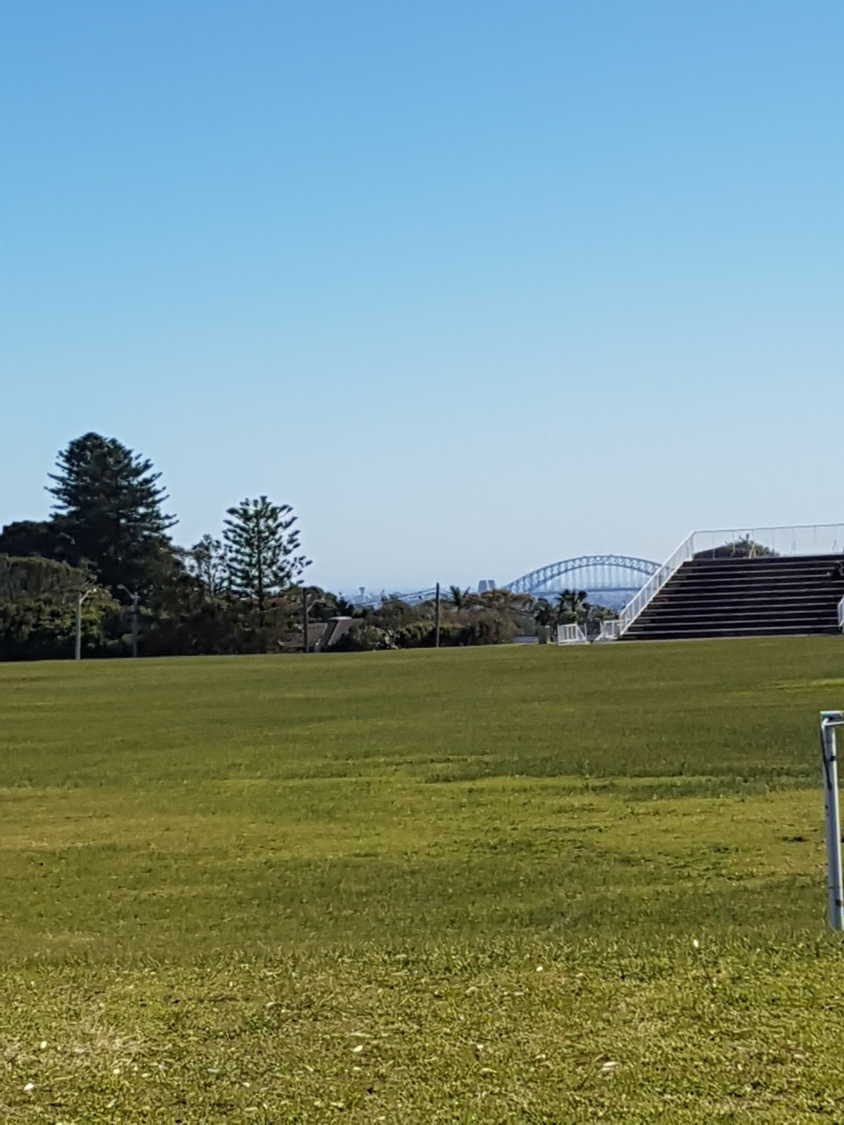
After a short pleasant walk downhill through the bush, with glimpses of the harbour views to come, you emerge (whichever path you have taken) at Clarke's Point reserve, a sweeping harbourside grassed reserve with spectacular views from the Iron Cove Bridge around to the Harbour Bridge.  Here I stopped to eat my sandwich in the glorious sunshine and think of my office-bound colleagues-that-were.  I decided I definitely had the better deal.

View from my seat at the water's edge

 
Refreshed in body and soul by the perfect combination of food, sunshine and sparkling water views, I meandered on around the water's edge, finally turning in to the cleft in the sandstone cliff that is the Woolwich Dock.

In 1898, the Morts Dock and Engineering Company (remembered in Balmain's Mort Bay) embarked on a massive engineering project on land purchased from the Clarke family.  Sound familiar?  Over the following three years, they excavated 85,000 cubic metres of sandstone to create what was then the biggest dry dock in Australia.  It has been used continuously since then for ship repairs and was especially busy during the two world wars.  It is a fascinating place to walk around.  I stopped to watch a boat being lowered into the water by modern machinery, and marvelled at the ingenuity required to construct such an industrial site over 100 years ago. 

From there, it's all downhill, once you've hiked up the hill through another park to emerge at the Woolwich Pier Hotel.  An opportunity to stop for a cleansing ale, if you're in the mood.  I headed down to turn around at the Woolwich wharf, where ironically a ferry that I didn't need was just pulling in.  At this point, I must not forget to compliment the public toilet facilities at the wharf.  Clean, working, with toilet paper, soap and even paper towel to dry your hands.  Thank you to the Council for their efforts to keep the burghers of the Hunters Hill peninsula well serviced whilst they await the ferry.

From there, it was a matter of retracing my steps back up the fairly extensive hill, but for the diversion where I found the track through Kelly's Bush that I had missed on the way down.  I had time for coffee before my infrequent bus, which was predictably very late.  I alighted to change to my connecting bus and stood on the wrong side of a busy intersection watching it pull up.  For the only time in my life, I was grateful for the disorganisation of a rabble of schoolchildren who took so long to board the bus that I was able to sprint up to its door just as the driver was about to close it and pull away.  And so I arrived back to pick up my car in fading daylight, having completed the first of Part 2.
 

To finish, a gentle touch of Hunters Hill humour... 


With thanks to the Dictionary of Sydney and the Sydney Harborside Trust for the historical insights, and special thanks to the Battlers of Hunters Hill. 


Wednesday, June 8, 2016

Part 2. Walking through Retirement

I have found myself suddenly and unexpectedly - to none more so than myself - being a person who has given a retirement speech, collected the flowers and left the building for the last time.  The reasons for this it seems will forever remain divorced from my knowing; nevertheless I am determined not to be a bitter divorcee.  And so I have embraced this opportunity with both feet and am now launching the non-awaited Part 2 of my blog.  As yet, I don't know how long this episode will last.  Part 1 took me through six months.  This may take me through six weeks, or six years.  Time will tell.

In the interim, I have worked more than full-time for close to six years (there seems to be a recurring theme of six) and consequently made little progress through the Book of Walks.  When I concluded Part 1, I had just completed Walk # 13.  Sadly, in the intervening years, I managed only seven more walks from the book, just slightly more than one per year.  In my defence, I have also recently joined a walking group, and done some walking that way too.  http://www.meetup.com/Sydney-North-South-East-West-Walks-40/  Thank you Bruce.  I tried to do one walk every birthday, taking the day off to celebrate in my own favoured style.  But there never seemed enough extra time to write about those walks.  I was too busy completing them, then walking straight back in the office door.

So Part 2 began yesterday.


Thursday, August 12, 2010

Not with a bang but a whimper

With apologies to T.S. Eliot, who famously described the end of the world, this is apparently also the way redundancy ends. On my last day of a glorious, difficult and tumultous period in my life, that began after I was unexpectedly made redundant, I have sat down to write about my last walk in the healing process. For although there are more walks to do, and I have committed to doing them, they will inevitably be weekend walks of a different character.

Walk #13, my last walk, by pure chance was a non-event. It happens to be so much of a local walk for me that I actually walk out my back gate to join the path that goes round Iron Cove. Consequently, I have done it many times, in company and alone, meeting friends along the way, in sunshine and once, famously, in driving hail. So it needs no planning.

On this official occasion, I had been out all day, and got home at dusk. I was at a celebratory lunch for a friend's birthday, so had wisely chosen to walk to and from the venue. By the time I arrived home, I felt I had done my day's quota of walking. But the dog, who had been cooped up in the back garden all day, had other ideas. It was getting too dark to take her on our routine walk down to the off-leash park at Hawthorne Canal, so we set off on the Bay Run. It's a 7 km circuit, some of it attractive and some not. I join it at the end of Lilyfield Rd, and always walk clockwise. This gets rid of the unpleasant noisy, smelly part of the walk along the busy CityWest Link first, and leaves the last part of the walk back through the tranquility of Callan Park. Even at night, this is still a preferable direction.

So we walked in the dark, and did our 7 kms. It felt like nothing more than exercise for the sake of it, but it tired the dog out at least.

Back to work on Monday.

Monday, August 9, 2010

Back to the bush, and back to the office

Lesson 1 for those who wish to use a dictaphone is that, if you leave it switched on when you finish using it, you will find that its batteries are flat when you next go to use it. So once again, the reminiscences of this walk are made from memories, though I did have the camera.


Elvina Bay is a tiny little town nestled at the head of McCarrs Creek in Ku-rin-gai Chase National Park. It's just near West Head, the site of one my earliest, and favorite, walks. It is distinguished by having no road access, other than for a fire track. Locals travel in and out by boat or on foot. Which is why, when you drive into Ku-rin-gai Chase along West Head Rd, and find yourself at the end of the road at West Head, you have done this because you have looked in vain for a sign of any substantial size directing you to the town of Elvina Bay. Oh well, it's a nice drive, and you also can take the opportunity to use the toilets at West Head before heading back in search of where you are supposed to have parked the car. The sign to look for is one of those small green NPWS wooden signs marking the Elvina Track. There's a small parking lot, but the whole thing is well screened by the roadside bushes. For reference, it's 2.3 kms past the toll booth, which is once again empty and locked up on this winter Monday.

Coming by car will have you starting near the "end" of the loop track as described in the book. The official way to arrive is by ferry from Church Point, but I wasn't sure how frequent the service would be on a winter weekday. Again though, like the Bundeena walk, this would be a lovely adjunct to this walk on a warmer day, and I will come back to try this option in the summer.

The track down to the town is the fire track, so it's easy to follow. Initially flat, it quickly heads steeply downhill. A pleasant walk, but not very challenging. There is a site where there are Aboriginal engravings close to the start of the fire track, on the right as you head towards the coast. Look out for a concrete block that marks the track junction. According to the book, there are "a group of three shields, a figure with a headdress, and a large emu". I found the latter two easily enough, but searched in vain for the group of shields. I did find two kangaroo engravings though, which the book doesn't mention, so I felt we were even at that point.

Although it is early August, the spring wild flowers have started to bloom, making the stroll through the bush picturesque. I even encountered a wallaby, of the real, as opposed to the carved, variety. There are some beautiful filtered water views as you come close to the town.

The township of Elvina Bay consists of some lovely houses stretched along the waterfront, serviced by a dirt track running behind the foremost ones. At every gate, there is a wheelbarrow, testament to how the locals transport their shopping from the ferry to home. It seems idyllic, but must be a bit miserable when it is cold, wet and dark. But to counter this, the hammocks strung out in the gardens tell of other, more appealing, aspects of the lifestyle. A second wallaby stared at me from someone's garden, then went back to its wallaby life.

I sat in the sun on one of the ferry wharves - incredibly, there are two wharves for the ferry, a north and a south one - and ate my lunch looking out over the bay, pondering the imminent end to my relaxed lifestyle. Yes, I am about to be employed again, having done only a third of the walks, and none of the full-day really taxing ones. I am surprised at my lack of progress, and a little disappointed that the winter inclement weather has kept me from walking as much as I would have liked. I make a promise to myself that I will complete my original plan to do every walk, even though now they will be with the weekend crowds. I treasure the solitude afforded to me at Elvina Bay, and hope always to remember the lessons I have learnt in the last six months about what really matters.

After lunch, I headed north to the end of the town. Here, the track turns back up the hill. Just after it starts, there are two simple tombstones that tell of a lonely life here in the mid-18oos. One is for Fredrick (sic?) Oliver, the other says simply F.O. Presuming that Fredrick didn't die twice, I wonder if this is perhaps father and son.
From here, the track is fairly basic, but there is a lovely deviation to a small waterfall with a rock pool that is well worth seeking out. When I did this walk, it had been raining heavily for the previous few days, so at times I was hiking uphill straddling the temporary creek that had formed in the rutted track. This meant that, watching my step as I was in the mud, I perhaps didn't appreciate my surroundings on the way up as much as they warranted. This is a charming walk, and in a few weeks, when all the flowers are blooming and the mud has dried, it will be even better.
I sat on a fence post in the carpark at the end, and ate my orange, and was content enough with my day.

Sunday, July 25, 2010

The dog

In the time since my last walk, we have acquired a dog. She is a lovely golden labrador and of course it seemed axiomatic that she would now come on my walks with me, when location allows. So a suburban north shore Harbour walk seemed the perfect place to start. This walk officially starts at McMahons Point and ends at Waverton, but as I intended to do the return trip, and it's easier to park at Waverton, I did it in reverse, starting at Balls Head Rd at the old BP terminal.


The first thing about walking with a dog is that, when she's only new, it's a bit like taking a baby out. By the time you remember the lead and the ubiquitous plastic bags and organise her into the car, both the camera and the dictaphone get left behind. And the second thing is that the whole nature of the walk is changed, so that the focus becomes the dog, and not the surroundings. This dog is not silly, and she has learnt that pulling on the handbrake is usually a signal that we have arrived. (Makes hill starts a point of confusion for her.) So as I pulled up to the kerb in Balls Head Rd and applied the brake, the dog was beside herself with excitement at being in this new place, with a plethora of smells to experience. She surged out of the car, with me trying to get the backpack onto my shoulders whilst wrestling with a lead that was fast being wrapped around my legs. Eventually we both gathered our composure and set off at a trot, the dog dictating the pace.


The first part of this walk takes you through the landscaped cliff park that marks the site of what was once the BP oil terminal. They've done a great job in converting industrial wasteland into a very attractive park, that speaks to its history without being dominated by it. In keeping with its industrial heritage, the stairs traversing the cliff face are those metal open-weave ones. It is at this point that I discover that the dog is terrified of them. Some time later, I have managed to half-coax and half-carry 25 kgs of dog down to the bottom of the cliff, and have chosen not to think too much about having to do the journey in reverse on the way back. I have not paid very much attention at all to the view, which is magnificent.


At the water's edge at the end of the BP park lies Waverton Park. Waverton Park is reached down a few flights of solid stone steps. Stone steps are completely safe in dog world, so she flies exuberantly down them, towing me behind. Somehow I stay upright. On a warm day, I would have stopped here to sit in the sun at the little beach while the dog had a swim, but the weather was cool, and threatening to rain, so we pressed on.


Private properties spill down to the water's edge at the eastern end of the park, and at this point you must take to the streets for a short and unedifying distance, before heading back down to another waterfront reserve known as Sawmillers Reserve. Here there is another small beach with a rusted boat hulk on the shoreline as testament to its working history, if the name isn't enough of a clue. This would be a pleasant park in which to picnic on a warm day, for there is plenty of shade.
At the end of the park, another short detour through the streets brings you out to Blues Point Reserve, and it is worth spending some time here absorbing the view. For those who know Sydney, Blues Point Reserve is notorious for being overlooked by Blues Point Tower. I use the word 'notorious' advisedly. Harry Seidler (the architect) might have built a controversial structure, but he certainly recognised a spectacular site when he saw it.
At the very tip of Blues Point, you can look straight under the Harbour Bridge to the Opera House beyond, framed in the arch of the Bridge. It's probably the most iconic Sydney image, and I wish I'd remembered my camera. But 1000s of photographers before me have taken the same photo, and I've since realised that the only missed shots I should mourn are those that you can't find on Google Images, photos such as the one of my tennis ball in the West Head post.
The dog, having been panting enthusiastically for the whole walk, is now clearly thirsty. She will happily drink from a tap, so I search in vain for a working tap. But, presumably because people left them running, all the handles of the public taps have been removed so that they can't be turned on. I try a few bubblers to see if they will have enough pressure to spout over the edge of the bowl, but for once they all appear to be in perfect working order for human use. We walk on round the corner to the wharf at McMahons Point, officially ending the walk, but the focus has shifted from the walk to solving the problem of the dehydrated dog. Some concerned workmen who are employed on the Blues Point harbour wall renovation join me in the vain search for a tap. I have visions of featuring on that Animal Rescue show, where irresponsible pet owners are pilloried on prime-time TV. Suddenly, I realise that the plastic bag I am carrying - as yet unused - has more than one potential use, and I hold it under the dribbling bubbler tap until it is full. With some encouragement, the dog lowers her nose into it and drinks. My pet-owning credentials are restored! We can now focus on the return trip, and the thought of those stairs awaiting us at the end.
My next walk involves a National Park again, so the dog will have to stay home. Oh dear, what a shame.

Tuesday, June 29, 2010

For David

After something of a hiatus, due to doing some walking overseas, various other priorities, and some most inclement weather, I am back walking the coasts and harbour of the greater Sydney area. Still a little with my head in Italy, I forgot to take my camera on this walk, so you will have to use your own imagination, dear reader.

This walk is one I have done before on a very memorable day. It's a loop walk from Bundeena in the Royal National Park, just south of Sydney. For those of you who don't know it, the Royal National Park is a spectacular major tract of bushland and coast that emerges suddenly from the suburban Sutherland Shire moments after turning in the gate. On a June weekday, the ticket booth is deserted, but entry to the Park will normally cost $11. Money very well spent. Once past the turn-off to Audley, there is nothing to see but bush-covered hills stretching to the horizon in all directions. It seems that you must have left Sydney behind many hours previously. As I drive, a flicker of movement high in the sky catches my attention, and I look up to see the hawk, but instead find the plane coming in to land at Sydney Airport. Coming round a bend, the high rises of Cronulla come startlingly into view, with greater Sydney stretching beyond.

Driving into the Park in my hermetically-sealed car on a glorious sunny day, it would be easy to believe that it is summer, save for the long winter shadows that already lie across the road in the early afternoon, and the t00-green verge. Last time I came here it was summer - January 26, Australia Day. I was with a very close friend, and we caught the ferry from Cronulla. If you can spare the time, this is a charming way to arrive in Bundeena.

A short walk from the small centre of Bundeena through pleasant suburban streets takes you onto the western end of Jibbon Beach. On Australia Day, there was barely a grain of sand not occupied by people, and the waterline was guarded by a flotilla of pleasure boats that formed such a barrier that there were few spots for swimmers to pass in between.

But today, despite the sunshine, I am for a while the only person on the beach. So I kick off my shoes and sit down in the sand to eat my lunch. Two seagulls watch me closely, and I wonder what seagulls eat when there is no-one to feed them chips. There is a parallel here with humans who survive on a diet of take-away food, and have lost the art of cooking. Do seagulls lose the art of fishing?
After lunch, I walk on down the length of the beach. A rustle in the vegetation bordering the beach catches my attention, and I am surprised at a kangaroo being so bold. But in fact, it is a deer. We gaze at one another with mutual curiosity before she turns back to grazing and I to walking. At the end of the beach, the path turns into the scrub and immediately I come upon a whole herd of deer; at least four that I count before they scatter. I imagine that they must be well-used to crowds in summer, and presumably keep away from the paths then. But today I am a solitary walker, and have broken the deer rules for when company is to be expected. Later, on my way back along the beach, I see the sign that explains that they are Rusa deer, and a significant pest, decimating the littoral rainforest and coastal vegetation, assisted by weed invasion and unauthorised camping. I feel a little guilty for having found pleasure in seeing them.
Heading along the coastal path towards Jibbon Head, there is a turn-off to the right that is worth taking. It leads to some Aboriginal rock engravings. Sadly, they are completely unprotected, so that if you wished, you could walk all over them, or even deface them. I step carefully around them on the soft rock. Some previous visitors have felt the need to leave their initials behind, to demonstrate their artistic and cultural inferiority. The carvings clearly show the Aboriginal interaction with the marine environment. There are two whales that dwarf the other carvings, just as they would in the real world. A stingray and a turtle swim past in the rock, and a lawman raises his hands above his head, as if being held at gunpoint. He has no face. I see the carved kangaroo that I had expected to see in reality a few minutes earlier.
Returning to the main path, I come round a corner to be entranced by an echidna ambling across my route. Remembering that they can only see objects if they are moving, I freeze, and spend a delightful few minutes watching it unhurriedly continue with its echidna day. Once it disappears, I look out to sea and have my earlier question about seagulls' fishing abilities probably answered. There must be a large school of fish there, attracting an equally large flock of seagulls. Many of the seagulls are floating in the water, but some swoop overhead, calling in that raucous cry that everyone learns from their first excursions to the beach. Perhaps the ones just floating have indeed lost the art of fishing.
The Jibbon Bombora breaks off shore, a wave that arises, swells and breaks seemingly out of, and into, nowhere. But sailors know it signals an underwater reef.
On the coastal side of Jibbon Head, the path is very wet and muddy, with pools of water lying around despite the sunshine. I pick my way carefully along. It is in remarkable contrast to the bayside path, which was completely dry despite being such a short distance away. Clearly it must have rained a great deal on this side as the weather drives in from the ocean. Focusing on trying not to slip over in the mud, I find myself suddenly at the end of the path, where it emerges onto Shelley Beach, and am hit by a wave of emotion with remembrance.
I mentioned earlier that I had last done this walk on Australia Day. That was the day after I had learned that I would be redundant; that my lovely job, which I had enjoyed so much for more than four years, would go to someone else. Despite Jibbon Beach having been horrendously crowded that day, Shelley Beach had been deserted, just like today. There is a lovely shallow rocky inlet there, where the water washes in with every wave. On that hot day, I sat there in the water for hours with my special and most supportive friend, and we talked. We talked and we talked, through all my fears and my anxieties and my grief.
Today, it is strange to see it again. At 3.30 pm on a wintry afternoon, the inlet is in complete shade, and the air is cool. I'm not quite sure how I feel. So much in my life has changed since that day I was first here. I didn't expect to feel such a complex range of emotions coming here again. I knew it would be a little bit challenging because of my history here. But being here makes me think about life, and of all the unexpected and rapid changes of direction that it can take. And how all of a sudden, sometimes nothing is as you thought it was only the day before. And how the changes may be for the better, and or maybe not. And they may be for the better for one person but not for another. And whether it's better or worse, it's sure different.